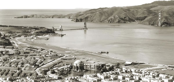
The Golden Gate strait is a gap in a mountain range that was cut by an ancient river that passed through what was a dry valley until 10,000 years ago. That was when sea level was over 100 meters lower than today. The melting ice caused by the end of the last ice age raised the level of the sea, and the ocean slowly flowed back up the river canyon to form San Francisco Bay. Today, 60% of the rain and snow that falls on the State of California still drains through the Golden Gate.
The Golden Gate strait is the reason for the strong tides, frequent winds, fog, and salt air, all of which posed challenges for building a bridge across it. In addition, the infamous San Andreas Fault, cause of the 1906 San Francisco Earthquake, is only 7 miles (11 kilometers) offshore.
Native Americans lived around San Francisco Bay at least 4,000 years ago. Once Spanish explorers discovered the many natural resources of the area and the desirability of the Bay as a harbor, they established in 1776 a settlement called Yerba Buena, later re-named San Francisco.
In 1848, the population of the city was less than 500; in 1849, because of the Gold Rush, it was suddenly ten times greater. Shortly after 1900 the Bay Region’s population had reached a million. The major north-south highway in California, Highway 101, needed to span the Gate to become a viable statewide transportation artery.
In the early decades of the twentieth century, civil engineering made dramatic advances in the design and construction of long-span bridges. A great bridge across the Gate, an impossible vision before then, became a challenging possibility. Despite political opposition, scarce funds in the Great Depression that began in 1929, and the immense physical challenges of bridging a mile of water, the people of six counties in northern California voted to finance the Golden Gate Bridge. Engineers and construction workers with imagination, courage, and determination then came together to design and build what until then had been considered “the bridge that couldn’t be built.”
Learn More
Explore this Topic Further
Bridge History
Key Dates in Bridge History from Golden Gate Bridge, Highway and Transportation District (all ages)
This timeline chronicles important events in Golden Gate Bridge history from 1846 when Captain John Fremont declared California independent from Mexico to the present day when two white-tailed deer stopped all traffic on the Bridge as they ran from San Francisco to Marin County.
Construction Timeline from Golden Gate Bridge, Highway and Transportation District (all ages)
This provides a summary of the key dates in the design and construction of the Bridge from December 1932 to April 1937
Major Projects on the Golden Gate Bridge from Golden Gate Bridge, Highway and Transportation District (all ages)
This web page summarizes the Bridge improvement projects between 1953 and 2008.
Golden Gate Bridge Chronology from PBS American Experience (all ages)
This timeline chronicles important events in the history of the Golden Gate Bridge from 1849 until 1994 when it was declared a Wonder of the Modern world by the American Society of Civil Engineers.
Geology and Earthquakes
Geology of the Golden Gate Headlands by William P. Elder, National Park Service (grades 6 to adult)
This 19-page document provides detailed discussion of the geology of the peninsular headlands just north and south of the Golden Gate. The article is divided into six field trip stops and provides a variety of maps, photos and references as well as a road log.
Field Trip Guide to the Golden Gate Bridge from the California Geological Survey (grades 6 to adult)
This 38-page document includes three articles: 1) Golden Gate Bridge Field Guide by M. Huang and J. Kao, 2) Early Geological Observations of the San Francisco Bay Area by S. M. Testa, and 3) the William Phipps Blake Report on the Geology of the Vicinity of San Francisco (1858).
Geology and Natural History of the Bay Area - Resources by S. Toussaint, U.S. Geological Survey (grades 5 to adult)
This 6-page list provides an annotated bibliography of resources about the biology, geology, topography, bathymetry, tectonics, earthquakes, tsunamis, groundwater, and surface water of the Bay Area.
Bay Area Earthquake Hazards from the Great Shakeout (all ages)
This web site contains numerous maps and other resources that describe Bay Area faults and earthquake-induced hazards.
1934 South Pier Geology Report by the Golden Gate Bridge Building Committee (grades 9 to adult)
This is the original report submitted to the Board of Directors of the Golden Gate Bridge & Highway District on November 27, 1934 documents reactions to Dr. Bailey Willis’s concerns about the geology conditions at the site of the south pier. (The name of the District later became Golden Gate Bridge, Highway and Transportation District.) (10 MB)
San Francisco Bay
San Francisco Bay Tides and Currents from the National Oceanic and Atmospheric Administration (grades 3 to adult)
Find out about the water level, current speed and direction, temperature, and salinity underneath the Golden Gate Bridge during the most recent 24 hour period.
Bay Model Visitor Center (all ages)
The Bay Model Visitor Center in Sausalito is a fully accessible education center administered by the U.S. Army Corps of Engineers that houses a three-dimensional working hydraulic model of the San Francisco Bay and Sacramento - San Joaquin River Delta System and is capable of simulating tides and currents. Free admission.
Formation of San Francisco Bay from the Bay Model Visitor Center (all ages)
This web page provides a very brief summary of how now San Francisco Bay formed and why 85 percent of the bay is less than 30 feet deep.
Fly Over the Seafloor of San Francisco Bay from U.S. Geological Survey (all ages)
This computer simulated fly-over of San Francisco Bay reveals the seafloor from the south and central Bay through the Golden Gate, as if the Bay were drained and one could see its bottom. It pauses over prominent seafloor features including, large sand waves, rock pinnacles, current scour pits, as well as many human impacts on the seafloor. (4:04 minute video)